
The Astronomy Picture of the Day website just put up their choices for Astronomy Picture of the Year 2007. Believe it or not, my personal favorite is not a photo of Mars. It's of the spectacular Comet McNaught from last January:
Showing posts with label Solar System. Show all posts
Showing posts with label Solar System. Show all posts
Tuesday, December 18, 2007
Astronomy Pictures of the Year


Wednesday, December 12, 2007
Spirit Rover has Camoflage!?
In this recent "deck pan" of the Spirit rover, the solar panels are so covered in dust that they blend in almost perfectly with the surrounding dusty martian surface.
All that dust means that the rover has less power to work with every day. With martian winter approaching in a few weeks, the Rover team has been working nonstop trying to drive Spirit to a location where the solar panels will be tilted toward the sun. The rover will camp there, trying to conserve energy until spring comes and there is enough power to drive once again.
Here's hoping for a gust of wind to clean off the panels and make life a little easier for Spirit...

Thursday, November 15, 2007
Big Comet!
Comet Holmes, the comet that suddenly brightened by a factor of several million a few weeks ago, has now expanded to a diameter of 1.4 million kilometers. That's bigger than the sun! Of course, its nucleus is still tiny, it's the coma, the cloud of gas around the nucleus that is so huge. Check here for more information.

Wednesday, November 14, 2007
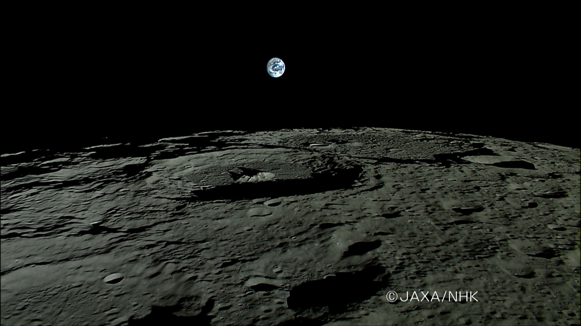
HDTV... from the Moon!
I'm a sucker for pictures of the earth from space, as you may have guessed from this blog's title image. So I had to point out these awesome pictures of earth setting over the moon taken by Japan's Kaguya spacecraft. Also, last week JAXA released a sample of the first HDTV transmission from the moon, taken by the same spacecraft.
I got the heads-up on both of these press releases from the Bad Astronomy blog, one of the best science blogs out there.
Saturday, November 10, 2007
Good MSL News!
Alan Stern, the Associate Administrator of NASA's Science Mission Directorate, and Jim Green, the director of NASA's Planetary Science Division, recently made a very welcome announcement to the Mars community. After a lot of work from everyone involved, the cost issues with both the descent imager MARDI and ChemCam have been resolved and the two instruments will be flying on MSL!
MARDI is a high-definition color video camera that will send back footage of MSL's landing. We will finally be able to watch a video of the landing instead of relying on telemetry to tell us what's going on and computer simulations to show what happened!
ChemCam is an instrument that sounds like it could be straight out of Star Wars. It uses a laser to vaporize a small amount of a target rock from up to 30 feet away, then analyzes the spectrum of light emitted by the superheated plasma to determine what the rock is made of. By repeatedly zapping the same place on a rock, it can blast away dust covering the surface, and even drill through thin coatings of alteration on rocks to find out how their composition changes below the surface. Finaly, since it has to have a powerful telescope to collect the plasma light, it is also able to take extremely detailed images from a distance.
It is great to hear that these instruments are both back on the mission. I'll keep you posted with other MSL developments as I hear about them.
Wednesday, October 31, 2007
Summary of MSL Landing Sites
Emily Lakdawalla has posted a really excellent summary of the landing site workshop in a long, but more coherent, post than the three that I made. Check it out.
Tuesday, October 30, 2007
Spooky Sounds from the Solar System
In the spirit of Halloween, NASA created this page where you can listen to audio representations of data from various solar system missions. Some of them, particularly Saturn's aurora, really do sound like they belong on a haunted house's playlist:
Spooky Sounds
Friday, October 26, 2007
2nd MSL Landing Site Workshop - Day 3: Judgement Day
What a day!
We began with a series of highly anticipated presentations about potential landing sites with evidence for salts, sulfates and clays – all types of minerals typically formed in water-rich environments that are favorable in terms of habitability.
The first presentation was on some new, unusual sites with strange, featureless spectra. Normally a featureless spectrum is nothing to base a landing site on, but some subtleties in the slope of the spectrum implied that it may be due to chlorides (such as sodium chloride – salt). When combined with the fact that many of these potential chloride sites appear at the bottom of basins, and that salt is excellent at preserving biological signatures within microscopic fluid inclusions in the crystals, and these new sites got quite a lot of attention.
Next came two presentations on a region called Mawrth Vallis. This region is carved by a huge channel, with lots of light-toned layers, and shows very strong evidence for clay minerals in those layers. Some of the potential landing sites were directly on the strongest clay signals, but looked like very rough and nasty places to land. Another potential site aimed for a much safer but less-interesting location – it would require some driving to get to the high-clay areas, but not too much.
Finally we heard a very compelling case for landing in a trough in Nili Fossae. This is another location with extremely strong evidence for clays, and they appear to be eroding from the walls of the canyon, implying that the rover would be able to investigate the clays where they formed and not just clay sediment that has been washed to the site from somewhere else. If that’s not enough, there is also ejecta from a nearby crater that contains clay minerals. Also, right in the landing ellipse there is a contact between the two earliest eras of martian history, so the rover could study what happened to cause the change. And wait, it gets better! The landscape just outside the landing ellipse is steep canyon ways and eroded mesas – they were compared to
With that, the presentations of potential sites were finished, and we began the painful process of trimming down the list. Throughout the three days of presentations, we assigned the sites values of red, yellow, and green in four scientific categories. Compiling those results, about 11 sites seemed to stand out above the rest. These included a wide variety: ancient river deltas, craters with layered rocks, potential hot springs, the safe (but interesting) meridiani plains, and of course, the sites with strong mineral evidence for past habitability.
Once the discussion period began, the meeting became (if possible) even more interesting, but also very chaotic. Sites with high “scientific risk” were gradually removed from the list: we don’t want to land somewhere without several lines of evidence that the site would answer our questions about the past habitability of mars. This placed the chloride sites and the potential
Melas Chasma, a site that was universally agreed to be fascinating, was eliminated because there was no way it could satisfy the engineering constraints. It required placing the ellipse in a small flat area on the edge of Valles Marineris, and with the new ellipse size (25 or 30 km diameter, rather than the original 20 km) there was no way to land safely.
We also heard some bad news from the engineers who model the winds on Mars. It turns out that the Nili Fossae trough, and two other high-ranked sites nearby, are in places with very high wind shear, which makes landing safely difficult. After some discussion, we put it to a vote, and decided that the science in Nili Fossae was just too compelling: “Damn the winds, full speed ahead!”
The final, longest discussion involved the interplay of a number of engineering and science factors. I will try to sum them up here: First, in choosing a landing site, we are restricted to latitude bands: if we choose a site in the south as the primary site, we have to choose a backup “safe” site that is also roughly in the south. Unfortunately, although the sites in the southern hemisphere are at low elevation (which helps when landing), most of them were not good “safe haven” candidates. Another problem was that they are all in the south, and it would be winter when the rover landed. Due to some trouble with the actuators, it is likely that the robotic arm and maybe even the wheels and camera mast, would be unable to move until spring or summer – so to land in the south might mean sitting dormant on the surface until it warms up, and even then only operating for half the year and going dormant for the other half. This sounds pretty bad, but the southern sites also happen to be the ones that show preserved river deltas and other extremely good evidence of long-standing water. The question was, are we willing to sacrifice operational time for the possibility of studying a location where we have excellent mineralogical and morphological evidence for standing water?
After a very long and painful discussion, in which at one point we were one vote away from eliminating the southern sites, we got two new pieces of information. The engineers and mission managers actually suggested that we keep some southern sites – if we don’t try, we don’t know how well we can make the rover work at such cold temperatures. They also told us that it is possible (though difficult) to choose a primary site in the south, and a safe-haven in the north (or vice-versa). With this information, we voted overwhelmingly to keep the southern sites on the table, with the understanding that if they were totally impossible, we still have some northern sites, as well as some sites in purgatory if all else fails.
Finally, we had to decide which northern sites to cull. After hearing the pros and cons of each site, we voted and decided to eliminate the
Nili Fossae –Pro: loads of clays eroding from the walls, monument valley, geologic contact between two eras; Con: Dangerous winds, most of the interesting stuff outside of the landing ellipse
Mawrth Vallis – Pro: Loads of clays, layered deposits, huge water-carved channel; Con: rugged terrain, or would land and have to drive to clays
Wednesday, October 24, 2007
2nd MSL Landing Site Workshop - Day 2
Today was a marathon of landing site presentations, ranging all over the martian globe, and targeting just about every potentially water-related feature on mars. The day began with a continuation of the topic from yesterday: layered craters. Geologists love looking at layers because, like the pages in a history book, we can read them and learn about the planet's past. It gets tricky though, because layers can form as sediment settles out of a lake (good for life), but layers can also form in volcanic eruptions (not so good for life). The more compelling arguments for past habitability come from sites that have layers that coincide with evidence for water-bearing minerals.
After hearing about layered craters, we moved on to a set of presentations about sites in and around Meridiani Planum. Although this is the same region where the Opportunity rover is right now, saying that we shouldn't go back to Meridiani because we've "been there" is like saying that you've seen all of Europe after visiting Paris. Paris is nice, and has a lot to see, but Europe is a big, varied place. Meridiani has some great advantages: it has a lot of evidence for water-bearing minerals (clays and sulfates), it has lots of layered rocks exposed by erosion, and there are a lot of flat, safe-looking locations.
Of the sites in Meridiani, one in the eastern part of the region really stood out to me. It would land in the area of Meridiani with the largest amount of hydrated minerals as seen from orbit, in a very safe area, right on top of a huge stack of layers. Plus it is one of the only places on the planet where clay and sulfate minerals appear to be very close to each other. One of the new theories about the history of Mars is that clays formed when the planet was wet and habitable, and sulfates formed as it was drying out and getting less hospitable. We really want to find out what caused the change between the clay-dominated era and the sulfate-dominated era, so landing at a site that has some of both could help us figure that out.
After the Meridiani sites, there were a bunch of presentations proposing sites that would land in various parts of the gigantic canyon on Mars, Valles Marineris. If you placed it on Earth, Valles Marineris would stretch from California to New York, and its walls are nearly as tall as Mt. Everest. On the one hand, that makes it a really fascinating place to study, but that also makes it very difficult to find a safe place to land. I suspect that most of today's discussion about these sites was an intellectual exercise - the sites are excellent places to go, but will almost all require a mission with pinpoint accuracy when it comes to landing there safely.
The final round of sites proposed today was a grab-bag. A couple of the presenters took a shot-gun approach and talked about three or four sites in one presentation. This made it difficult to really assess whether the sites would be good places to land, because there was less detail about each individual site. In general, those sites didn't do well in the voting. Other presentations toward the end of the day talked about so-called "chaos" regions, where the ground has collapsed as vast amounts of subterranean water burst out and formed massive outflow channels. Still others proposed landing in the outflow channels themselves, or in locations where volcanic and water-formed rocks meet.
All in all it was a day full of really fascinating presentations. It was interesting to see the different degrees of candor in people's presentations. Some tended to gloss over the ambiguities in their proposed site, hoping to convince everyone that a water-related origin is the only explanation. Other presentations were brutally honest about their viability as a site, and in fact served more as public service announcements, reminding us of things to keep in mind when evaluating other sites. Of the sites discussed, some were clearly better than others, but I wouldn't say that there are any that I can say are sure to be among the finalists. I think that the group is doing a good job of asking the hard questions and really searching for sites that have multiple lines of evidence that point to past habitable conditions. Tomorrow should be very interesting as we hear about the rest of the proposed sites, and then go about the painful business of narrowing down to five top choices.
2nd MSL Landing Site Workshop - Day 1
Today was the first day of the 2nd Mars Science Laboratory landing site workshop in Pasadena. We began bright and early by cramming into the conference room and reviewing the goals of the mission, the goals of the meeting, and some of the constraints that we need to keep in mind as we decide on a landing site.
The mission science goals are to assess the past and present habitability of Mars by studying the geology and geochemistry of the landing site, searching for signs of biology (past or present), seek evidence of processes that influence the habitability, and study the current radiation environment. To do this, MSL has a pretty impressive suite of instruments, described here.
The goal of this meeting is to get the community together to narrow down the more than 50 potential landing sites to about 5, including a "safe haven" site and an "uber safe haven" site. There are some pretty strict engineering guidelines that must be followed, such as avoiding sites with steep slopes, lots of rocks, or at high elevations. In addition, we ideally want the sites selected to be scientifically interesting.
After hearing from the engineers this morning, we heard from representatives of some of the major data sets, including HiRISE (high resolution imaging), OMEGA (mineralogy), and CRISM (better resolution mineralogy). There was a lot of discussion of what certain minerals mean for the past habitability of Mars, and it looks like clay minerals, which generally form in water-rich environments, are pretty good at preserving evidence of life. This is because clay mineral crystals form thin sheets, which can sandwich organic molecules between them.
In the afternoon, we began to hear from some of the proposed sites, grouped roughly by category. Today's category was "layered deposits in craters", and there were five very interesting sites proposed. All of the sites had some form of evidence suggesting that the crater may have been filled with water at some point. Most compelling were a couple of craters that have the remains of river deltas clearly exposed. River deltas only form when a fast-moving stream encounters a slow moving body of water and drops its sediment, and they imply long-term stable water, which is obviously good for habitability.
We finished off the day by attempting to rank the sites in terms of how well we think we know their geologic context, their potential as past habitable environments, their potential for preserving evidence of habitability and how well the MSL instruments can asses the habitability. This was a pretty difficult process, because we were only allowed to rank each site as "red", "yellow", or "green" in each category. In most cases, this was a very ambiguous decision, and we literally went around the room and took a show of hands.
It was a very full day, and the next two days should be even busier. I'm looking forward to seeing where this process leads us at the end of the day on Thursday.
For another (less rambling) perspective on the meeting, check Emily Lakdawalla's posts at the planetary society blog.
Subscribe to:
Posts (Atom)


